In a significant archaeological breakthrough, a team from University College Dublin, alongside Serbian and Slovenian colleagues, has uncovered a vast network of ancient megastructures in Central Europe’s south Carpathian Basin.
These findings could explain the emergence of Europe’s Bronze Age megaforts, some of the largest prehistoric constructions seen before the Iron Age.
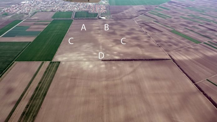
Using satellite imagery and aerial photography, the researchers stitched together a prehistoric landscape revealing more than 100 sites.
These discoveries belong to a complex society and indicate the use of defensible enclosures, a precursor to the later hillforts of Europe.
Lead author Associate Professor Barry Molloy from UCD School of Archaeology highlights some of the largest sites, known as mega-forts, like Gradište Iđoš and Corneşti Iarcuri.
The latter, enclosed by 33km of ditches, is notably larger than contemporary fortifications of the Hittites, Mycenaeans, or Egyptians.
The research, detailed in the journal PLOS ONE, uncovers these sites, collectively named the Tisza Site Group (TSG), located near the Tisza river.
This network suggests a cooperative community spread across multiple locations, with most TSG sites situated within 5 km of one another and aligned along the river corridor.
This newly discovered network indicates that the TSG was a significant innovation center in prehistoric Europe.
It formed a major hub around 1500–1200 BC, a time when the Mycenaeans, Hittites, and New Kingdom Egypt were at their peak. The society’s advanced military and earthwork technologies likely spread across Europe following their collapse in 1200 BC.
Molloy explains that this discovery challenges many aspects of European prehistory. It is improbable for each of these 100+ sites to be individual chiefdoms in competition.
The research offers more than just locations; it provides detailed maps of site sizes, layouts, and even the locations of homes within these settlements, offering an unprecedented view of Bronze Age life.
The period was not peaceful, marked by major innovations in warfare and organized violence. These societies were equipped to defend their territories and influence, indicating their relevance and power on a European scale.
Employing cutting-edge technologies, including satellite images, the team unearthed this unknown network of massive sites.
Their findings also include survey, excavation, and geophysical prospection data. Most sites were established between 1600 and 1450 BC and collapsed around 1200 BC.
This period, around 1200 BC, was a turning point in Old World prehistory. Kingdoms, empires, cities, and entire societies collapsed within a few decades across southwest Asia, north Africa, and southern Europe.
This research adds new dimensions to our understanding of these crises, revealing previously unknown societies and their ties to influential civilizations of the era.
It also reflects on the ephemeral nature of civilizations, as these powerful structures eventually shared a fate similar to other great powers of their time.


