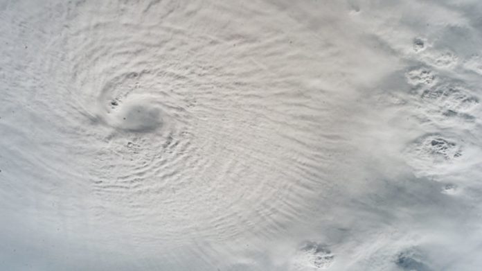
We often talk about Jupiter’s Great Red Spot quite candidly but forget that hurricanes can be devastating, destructive forces here on Earth.
Hurricane Milton is a reminder of the awful effects here on Earth.
It came out of nowhere, appearing in the Gulf of Mexico as a tropical storm and two days later was a category 5 hurricane.
It tracked a course and hit land near Siesta Key in Florida. NASA have been tracking the storm from space, recording high sea temperatures that fuelled the storm allowing it to grow.
Images have been released from the ISS showing the sheer enormity of the hurricane.
Hurricanes form over warm oceans, typically in tropical regions of Earth.
Their formation tends to start as a collection of thunderstorms over bodies of water where the temperature is at least 26.5 degrees celsius.
The warm, moist air over the ocean rises creating a region of lower pressure at the surface.
The low pressure causes air to flow inward, warming and rising as it goes. It then cools and condenses to form clouds that release the heat.
The heat then warms the surrounding air creating a continuous cycle of rising warm air and an inward movement of air. The system grows and eventually takes on a rotational movement due to the rotation of the Earth.
When the winds are recorded to be sustained above 119 kilometres per hour, it is classed as a hurricane. They can continue to grow as long as their is a source of warm moist air so typically they hit landfall and start to weaken.
The inhabitants of Florida only just recovered from the effects of Hurricane Helene before warnings were received from another hurricane brewing over the Gulf of Mexico. Hurricane Milton started to form on 5 October and two days later had become a category 5 hurricane. Fuelling this leviathan of a hurricane are the higher than average sea temperatures in the Gulf of Mexico.
Milton’s wind speeds rapidly increased from 28 to 281 kilometres per hour in 24 hours as the hurricane strengthened.
It wasn’t just warm oceans that intensified Milton so rapidly though, vertical wind shear was also a vital component.
This change in winds with height interacts with the brewing thunderstorms to usually diminish a hurricanes ferocity.
In the case of Milton, it was in a low-shear environment which means with changing altitude, there is usually very little difference in wind speed or direction. This allowed the storm to grown without being checked.
The National Hurricane Centre (part of the National Oceanic and Atmospheric Administration) have been tracking Milton since its formation, paying particular attention to where it was likely to hit land and what path it was likely to follow.
They were also able to determine (largely from imagery and data from orbiting infrastructure) that an eye-wall replacement cycle had completed. This process occurs when a new eye begins to develop around the old eye.
The new eye slowly decreases in size and eventually replaces the old eye. Events such as these can cause the hurricane to grow but reduce wind speed. It can happen several times but then grow in intensity again if the conditions permit.
With astronauts on board the space station and the remote sensing technology available to them, NASA are a key part of disaster management teams.
Their Disasters Response Coordination System has been used to support agencies dealing with the storm on the ground.
They provide maps, images and data to help manage flooding, power outages and rain fall levels.
Our thoughts go out to all those effected by Hurricane Milton from all the team at Universe Today.
Written by Mark Thompson/Universe Today.


