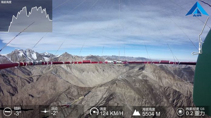
China has successfully developed and deployed its first helicopter-borne magnetotelluric detection system, a major breakthrough in geological surveys.
Created by the Aerospace Information Research Institute (AIR) of the Chinese Academy of Sciences, this system is now being used to support railway construction in high-altitude regions.
Building railways in mountainous regions presents major challenges.
The railway route passes through permafrost zones and high-altitude areas ranging from 2,500 to 5,000 meters above sea level.
These areas are prone to landslides, earthquakes, and debris flows, making traditional ground surveys difficult and time-consuming. The extreme weather and rough terrain further complicate the process, increasing the risk of delays and safety hazards.
To overcome these obstacles, China is using airborne electromagnetic (AEM) detection technology.
This method allows scientists to explore mineral resources, groundwater reserves, and geological structures by detecting differences in underground electrical conductivity. AEM technology has several advantages:
- Faster surveys covering large areas in a short time.
- High accuracy in detecting underground features.
- Ability to operate in difficult terrains where ground surveys are impractical.
This system is especially useful in plateau regions, dense forests, deserts, and marshlands, where traditional survey methods struggle.
Associate Researcher Huang Ling from AIR explained that the new airborne magnetotelluric detection system integrates three key technologies:
- A highly sensitive magnetic sensor to detect weak signals.
- A powerful signal processing system to analyze complex environments.
- A stable flight pod for high-altitude operations.
Over two months, the research team flew 5,000 kilometers under extreme cold conditions, gathering crucial geological data.
They successfully mapped deep-seated faults, underground water sources, and rock formations. This information is critical for identifying geohazard zones, ensuring the new railway is built on stable and safe ground.
This helicopter-borne survey system marks a major step in China’s efforts to improve infrastructure in challenging landscapes.
By providing accurate geological data, it enhances railway safety and stability, reducing risks associated with natural disasters. This innovative technology could also be applied in future projects, making construction safer and more efficient in difficult terrains worldwide.
Source: Chinese Academy of Sciences.


