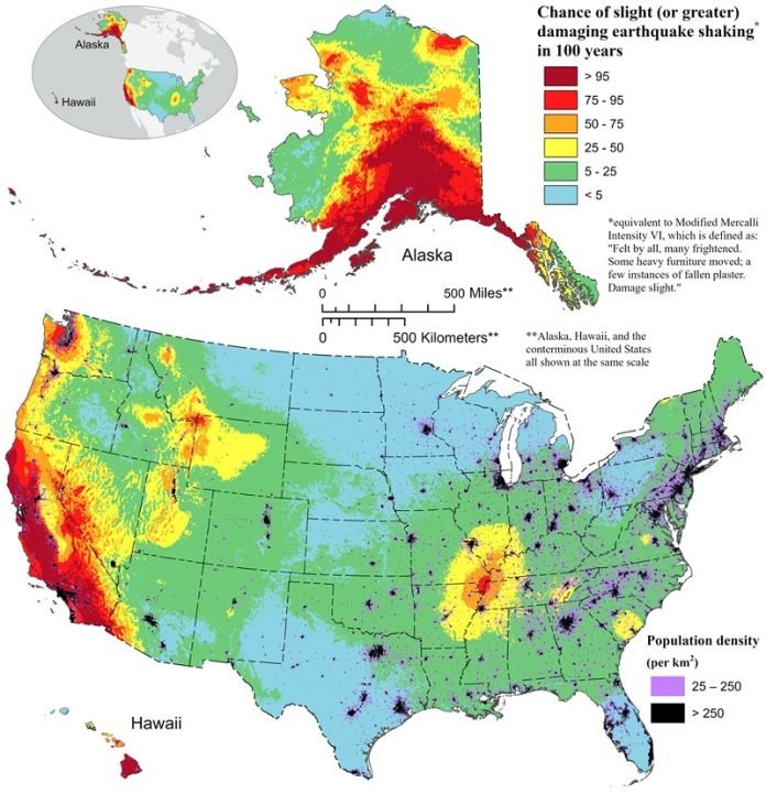
Imagine having a map that shows where the ground is most likely to shake in the U.S. – a map so detailed it could help keep millions of people safer.
This is now a reality, thanks to a team of over 50 scientists and engineers led by the U.S. Geological Survey (USGS).
Their latest project, the National Seismic Hazard Model (NSHM), reveals that nearly three-quarters of the U.S. could face the threat of damaging earthquakes.
This new, color-coded map is not just a regular map.
It’s a result of combining knowledge from past earthquakes, studies of the Earth’s movements, and advanced technologies.
Published in the journal Earthquake Spectra, this map is a key tool for understanding where dangerous earthquakes are more likely to strike.
Earthquakes can strike without warning, and knowing where they might hit hardest is crucial. This map is specially designed to help engineers and planners build safer communities.
It shows where earthquakes might occur and how strong they could be. This information is vital for constructing buildings that can withstand these shakes.
One of the most striking findings from this research is the identification of nearly 500 new faults – cracks in the Earth’s surface where earthquakes can happen. This discovery shows how our understanding of earthquake risks is always growing and changing.
Mark Petersen, a USGS geophysicist and the lead author of the study, emphasizes that this project is a huge team effort. It involved government agencies at all levels and private sector partners. This collaboration has led to a significant step forward in protecting people from earthquake hazards.
The NSHM has been updated several times, with previous versions published in 2018, 2007, and 1998. This latest version is the first to assess earthquake risks for all 50 states. It shows some notable changes, such as an increased risk of damaging earthquakes along the central and northeastern Atlantic coast, including major cities like Washington D.C., Philadelphia, New York, and Boston.
California and Alaska, known for their seismic activity, also show potential for stronger shaking. Additionally, Hawaii’s risk has been updated due to recent volcanic eruptions and seismic activity.
The key takeaways from the NSHM are eye-opening:
- Risk to People: An estimated 75% of the U.S. population could experience significant earthquake shaking.
- Widespread Hazard: Earthquakes aren’t just a West Coast concern. In the past 200 years, 37 states have had earthquakes with a magnitude over 5.
- Impact on Building Designs: This map will guide how buildings and structures are designed, ensuring they are better equipped to withstand earthquakes.
- A Unified Approach: For the first time, a single model considers earthquake risks for the entire nation.
- Understanding, Not Predicting: While predicting earthquakes is impossible, this map helps us understand where they are more likely to occur and how strong they might be.
This comprehensive map is a big step in earthquake research, offering a clearer picture of seismic risks across the United States.
It’s a vital tool for making the country safer in the face of one of nature’s most unpredictable forces.


