In a thrilling update from Mars, scientists have made a groundbreaking discovery thanks to the Perseverance rover.
At the heart of this discovery is the Jezero crater, a fascinating spot on Mars that has been under close watch.
Recent research, led by experts from UCLA and the University of Oslo, has revealed something incredible: this crater once held a lake!
Published in the journal Science Advances, this study is a big deal because it adds to our understanding of Mars’ past.
The researchers found that a long time ago, the crater was filled with water, forming a lake that left behind layers of sediment.
Think of sediment like the pages of a history book, each layer telling a story about the past. Over time, the lake got smaller, and a river that flowed into it created a huge delta, much like the ones we have on Earth.
Understanding the Jezero crater’s history isn’t straightforward. From space, we can see various deposits, but it’s like looking at a finished puzzle without knowing how the pieces came together.
David Paige, a professor at UCLA and the lead author of the paper, explains that to really get the story, we need to look beneath the surface.
Enter the Perseverance rover. About the size of a car and equipped with seven scientific instruments, it’s been exploring this 30-mile-wide crater since 2021.
It’s been busy studying the geology and atmosphere of Mars and collecting samples.
These samples are super important because they will eventually be brought back to Earth by a future mission. Scientists are excited because they might contain evidence of past life on Mars.
From May to December 2022, Perseverance had a major task. It drove from the crater floor up onto the delta, which is an area covered with 3 billion-year-old sediments. These sediments are a treasure trove of information, similar to river deltas on our planet.
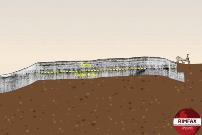
The rover used a special instrument called RIMFAX, which stands for Radar Imager for Mars’ Subsurface Experiment.
This instrument sent radar waves into the Martian ground and then measured the echoes that bounced back. This allowed scientists to see about 20 meters below the surface, like using X-ray vision to look under Mars’ skin.
This radar imaging is pretty neat. It’s almost like having a superpower, as Paige jokingly says. The radar revealed two distinct phases in the crater’s history, where sediments were laid down and then eroded away.
The crater floor beneath the delta isn’t flat, indicating a period of erosion before the lake sediments were deposited. The sediments are regular and horizontal, just like those in Earth’s lakes, confirming previous suspicions about the lake’s existence.
A second phase of sediment deposition happened when the lake’s level changed, allowing the river to form a broad delta. This delta once stretched far into the lake but has since eroded back.
Paige highlights how the changes recorded in the rock tell us about big shifts in Mars’ environment. It’s fascinating that such a small area can reveal so much and help us understand the bigger picture of the entire crater.
This research, funded by NASA, the Research Council of Norway, and the University of Oslo, isn’t just a scientific achievement; it’s a window into the past of a distant world, opening up possibilities for what we might discover next about Mars.


