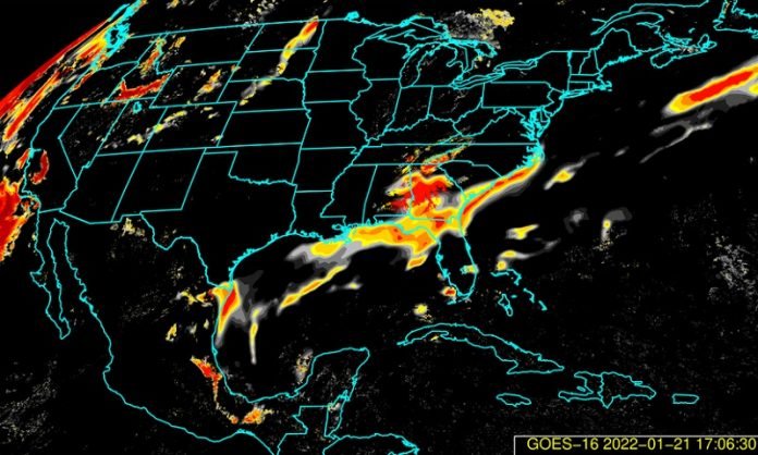
The software uses machine learning techniques with near real-time data from weather satellites to monitor conditions 24/7 and issue potential fog warnings.
Fog and low stratus clouds over airports can create dangerous travel conditions that result in costly delays and disrupted travel plans.
The US National Weather Service offices monitor and issue warnings when conditions are favorable for the formation of fog and low-level clouds.
These warnings are used by the airlines to anticipate conditions, avoid delays and reroute flights if necessary.
Now, the NWS uses a new fog detection software developed by scientists at the University of Wisconsin-Madison Cooperative Institute for Meteorological Satellite Studies and NOAA to assist with those warnings.
The software (known as a satellite product), is a result of more than 10 years of collaboration between CIMSS and NOAA.
It uses machine learning techniques with near real-time data from weather satellites like NOAA’s GOES-East and -West to monitor conditions 24/7 and issue potential fog warnings.
“As of late 2020 the GOES-R Fog and Low Stratus product is fully operational in NWS offices around the country,” says Michael Pavolonis, NOAA Advanced Satellites Products Branch physical scientist.
“The product provides around the clock monitoring of hazardous foggy conditions from Utqiagvik, Alaska to Key West, Florida.”
Fog occurs when a cloud forms near the ground, reducing visibility to below 1 kilometer (.6 miles). While it may be easy to identify fog during the morning commute or looking out the window, determining the size of the fog patch over a large area remains a challenge, especially for satellite observations.
Earlier fog detection systems would use comparisons between satellite data in the visible and infrared frequencies, but were largely limited to conditions where no other clouds were present above the fog.
Additionally, previous techniques were limited to nighttime use due to interferences associated with reflected sunlight.
And unlike thunderstorms that contain larger rain drops and ice crystals, fog is composed of much smaller droplets that do not show up on radar.
“To improve the system, we incorporated other atmospheric data used in Numerical Weather Prediction algorithms,” says CIMSS Scientist Corey Calvert. “This helps identify the type of fog over an area by evaluating every pixel in an image and generating a probability of the presence of fog and its intensity.”
In addition to identifying the presence of fog, the product is helping the airlines to avoid delays that translate into millions of dollars each year.
According to an analysis by the Federal Aviation Administration, weather was responsible for nearly 70 percent of flight delays from 2008–2013 which translates to real costs. Each hour of delay costs airlines from $1,000–$4,000 per flight.
The GOES-R Fog Product was designed based on needs from the aviation industry which has different requirements depending on the aircraft. Small airplanes for example, rely on a different set of rules when it comes to weather because they lack the advanced instrumentation of the larger airliners.
The Fog Product identifies dangerous conditions for both types of aircraft and can be used to issue warnings around the country, avoiding costly delays and making air travel safer.
“People who travel might not know the origin of this product or what is happening behind the scenes,” says Pavolonis. “But this is a great example of how the public benefits from university and government collaborations like this.”
Written by Eric Verbeten.


